There are no active watches, warnings or advisories for zone MAZ020.

NWS Northeast Regional Radar WU North East Satellite
Radar/Satellite images courtesy of NOAA/NWS and Weather Underground.
spacer
METRIC | IMPERIAL
Updated: 24-Mar-2023 @ 11:35am  
Temperature Current Conditions Forecast / Storm Prediction
Currently Outside: Warmer 1.1°F than last hour.

46.8°F

Feels like:  43°F
---
High Today
53.1°F
1:17 AM
Low Today
42.9°F
7:37 AM
Yest High
54.4°F
1:35 PM
Yest Low
46.4°F
2:33 AM
Sta* High
60.2°F
2021
Sta* Low
17.3°F
2014
* This Station's Records Since 12/2012
Overcast Overcast

Wind from NW Wind:  NW
6.7

Gusting to:
4.0 mph
Current Rain Rain:
0.00 in
Fire Weather Index: MINIMAL Current FWI:4
Fire Danger:
0.6 of 232
This
Afternoon
Partly Sunny
Partly Sunny
Tonight

Partly Cloudy
Partly Cloudy
Saturday

Chance rain
Chance rain
Hi <55°F Lo <35°F Hi <45°F
SPC Activity Map
Dew Point Liquid Precipitation Wind Speed Sun/Moon
Current: Increased 0.4°F since last hour. 38.9°F
Last Hour: Increased 0.4°F since last hour. 0.4°F
High 12:00 AM: 53.0°F
Low 9:53 AM: 37.9°F
Record High: 105.6°F on
26-Oct-2022
Record Low: -24.9°F on
27-Oct-2022
Wetbulb: 43.4°F
Rain Today
rain graph

Today: 0.00 in
Storm Rain: 0.08 in
Yesterday: 0.08 in
Last 7 Days: 0.09 in
Mar Rain: 3.07 in
Mar to Date
  Avg:10
1.80 in
Mar to Date
  Diff from Avg:10
Over 1.27 in for the month 1.27 in
Mar Avg: 2.80 in
Diff from Avg: Over 0.27 in for the month 0.27 in
Season:1 9.58 in
YTD
  Avg:11
7.19 in
YTD
  Diff from Avg:11
Over 2.39 in for the year 2.39 in
Last Rain
Time/Date:
23-Mar-2023
at 4:11 PM
34 rain days in 2023
8 days in March
0 days since last rain
Current: NW  6.7 mph
1Hr Average: 6.0 mph
Wind Run: 55.43 miles
Wind Gust
Current: 4.0 mph mph
Today: 19.6 mph 3:35 AM
Month: 34.0 mph 15-Mar
Year: 45.0 mph 3-Feb
Record Gust: 50.9 mph
25-Jun-2022
Sunlight:
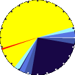
12 hrs 19 min
of Sunlight Today
graph 51.3% 48.7%
Which is
2 min 51 sec Longer
Than Yesterday
 
Evening Crescent, 2 days, 22 hours, 17 minutes in cycle
9%
Illuminated
Humidity Barometer
Current: Decreased 2% since last hour. 74%
Last Hour: Decreased 2% since last hour. 2%
High 12:00 AM: 100%
Low 11:26 AM: 73%
Record High: 100%
17-Mar-2020
Record Low: 0%
30-Jun-2020
Current: Rising 0.01  inHg/hr 29.912 inHg
Last Hour: Steady
High 11:04 AM: 29.916 in.
Low 12:36 AM: 29.690 in.
Record High: 30.788 inHg
16-Feb-2022
Record Low: 28.963 inHg
12-Mar-2022
Heating Degree Days Tide Wind Chill Air
Today: 7.3
Mar: 576.2
2023 to Date: 2047.7
Cooling Degree Days
2023 to Date: 0.0

4 hours, 56 minutes to low tide at
04:36 PM EDT


Current: 43.5°F
Low 7:45 AM: 37.3°F
Yesterday: 43.9°F
Record: -26.4°F
4-Feb-2023
Quality
Index6:

38


Good
Density:
1.25 kg/m3
UV Summary/Forecast Solar Summary
Mar-24

Mar-25

Mar-26

Sunrise is at: 6:42 am
Solar Noon: 12:51
Sunset is at: 7:01 pm
Almanac Snow3 Station All Time Records Cloud Level
Currently: Morning
YTD Avg Temp: 38.8°F
Sunrise: 6:42 am
Sunset: 7:01 pm
Moonrise: 8:10 am
Moonset: 9:27 pm
Full Moon: 06-Apr-2023
New Moon: 04:13 UTC
20-Apr-2023
Today: 0.00 in
Yesterday: 0.00 in
Mar Snow: Under 4.016 in for the month 0.00 in
Mar Avg: 4.02 in
Diff from Avg: -4.02 in
Season Total:2 0.00 in
Snow Depth: 7.50 in
0 snow day in March
0 snow day this season.2
HIGHS: LOWS:
116.4°F
27-Oct-2022
-7.7°F
4-Feb-2023
Daytime Records
  90.9°F
27-Jul-2020
  5.2°F
04-Feb-2023
Nitetime Records
  81.3°F
28-Jul-2020
  -1.3°F
04-Feb-2023
ICN:18 | S3C2:2 | Ajax 3.xx
ISS:Ok | CON:4.6 | RCP:98%
1 Rain season: Jan 1st to Dec 31st.   4 Updated at Noon Central Time.   6 Air Quality Index is provided by Minnesota Polution Control Agency and is updated hourly between the hours of 6AM and Midnight.   10 Historical average only to day 24 of just the month of March for this station since 2012.   11 Historical average rain this season to day 24 of March for this station since 2012.
 NWS Weather Forecast  -   Outlook This Afternoon & Tonight
This
Afternoon
Partly Sunny
Partly Sunny
Hi <55°F
NWS forecast: Partly sunny. Highs in the lower 50s. Northwest winds 5 to 10 mph.
Tonight

Partly Cloudy
Partly Cloudy
Lo <35°F
NWS forecast: Partly cloudy. Lows in the lower 30s. North winds 5 to 10 mph.
 NWS Short Term Weather Forecast
Saturday

Chance rain
Chance rain
Saturday
Night
Chance rain
Chance rain
Sunday

Sunny
Sunny
Sunday
Night
Mostly Clear
Mostly Clear
Monday

Partly Cloudy
Partly Cloudy
Monday
Night
Partly Cloudy
Partly Cloudy
Tuesday

Partly Cloudy
Partly Cloudy
Hi <45°F Lo >35°F Hi >55°F Lo >35°F Hi <55°F Lo ≈35°F Hi <55°F
Version 6.95 - 05-Jan-2016 - Script Mods by: BurnsvilleWeatherLIVE.com


Random Weather Facts

Weather Terms
Watch - A watch is used when the risk of a hazardous weather or hydrologic event has increased significantly, but its occurrence, location or timing is still uncertain. It is intended to provide enough lead time so those who need to set their plans in motion can do so. A watch means that hazardous weather is possible. People should have a plan of action in case a storm threatens and they should listen for later information and possible warnings especially when planning travel or outdoor activities.

Weather History for March 24